|
|
BRIEF
PROFILE AND STATISTICS
PROFILE
LOCATION
( INCLUDING BOUNDARIES AND AREA )
The district lies between 19-51' and 21-17' north latitudes and 75-57'and 76-98'East longitudes. It is bounded on the North by Khandawa district of Madhya Pradesh, on the south by Parbhani district on the West by Jalana and Jalgaon districts and on the North East by Amravati District.
Buldana district is predominantly an agricultural district having 967100 hectares geographical area of which 698300 hectares are under gross cultivated area.
ADMINISTRATIVE SET-UP
Buldana district is one of the four districts of Amravati Revenue Division in Vidarbha Region of
Maharashatra. The district is covering 1404 villages into 5 revenue subdivisions and 13
Tahsils viz. Buldana, Deulgaon Raja, Lonar, Mehkar, Sindkhed Raja, Khamgaon,
Chikhali, Shegaon, Sangrampur, Jalgaon Jamod, Nandura, Malkapur & Motala for administrative purpose. As per Zilla Perishad Act 1961, a parallel setup of Zilla Perishad at district level and Panchayat Samities at block level comes in to existence in 1962. This has been undertaken particularly for intensive development of area with greater participation of public in the affairs of government. As per Zilla Perishad set up, 13 Pnachayat Samities are established in the district.
TOPOGRAPHY
The district consists of 13 tahsils, of which Are :-
Buldana, Chikhali, Deulgaon Raja, Mehakar, Sindkhed Raja and Lonar lie on the Balaghat Plateau,
While rest seven tahsils viz. Khamgaon, Shegaon, Sangrampur, Jalgaon
Jamod, Nandura, Malkapur and Motala are in the great plain below known as the Panchayat. These are the two natural sub divisional setup of the district. Numerous deep ravines intercept the edge of the plateau where it falls abruptly in to the valley.
The landscape is of varied character fertile village alternating with barren hillsides and deep ravines. Below the ghat, the land is flat except where it is broken by spurs of hill putting out in to a plain, the general slope of the district above the ghat is from north to south.
SOILS
The soils are derived from trap rock of volcanic origin.There are three main categories of soils in the district viz.
1.Bhurkati: Which is deep black soil of a very fine texture and moisture
retentive.
2.Morand: Which is black cotton soil and
3.Barad: Which is the soil of the higher of the plateau & black, brown or reddish in color shallow.
The soil in the northern tahsils viz. Jalgaon Jamod, Sagrampur, Shegaon, Nandura, Malkapur & Motala are generally deep black formed by transported materials washed from the ghat lands. Cotton, Jawar and Groundnut etc. are the main crops grown in this area. On the plateau i.e. remaining six tahsils, area of medium black soils and are suitable to grow cotton, Jawar, Pulses and
Bajara.
RIVERS
The principal rivers in the district are Painganga and Purna. The important rivers are the Kadakpurna, Nalganga, Vishwaganga, Gyanganga and Banganga. The principal tributaries of Purna are Nalganaga, Viswaganga, and Gyanganga from the south. There are two medium irrigation projects on the river Nalganga & Gyanganaga in the district.
FORESTS
The forests coverage of the district is only 11.92% (1151.83 sq. Kms). forest area is located in Gavilgad hills in the north and Agentha hills in the south of the Buldana district. Dense forests are observed in Buldana, Khamgaon and Jalgaon Jamod
talukas.
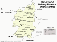
RAILWAYS
The length of the broad gauge railway line in the district is 90.14 kilometers. Mumbai-Calcutta railway line is passing through this district. Malkapur, Shegaon are the main stations on this route.
ROADS
Mumbai- Calcutta National Highway No. 6 is passing through Buldana District. Moreover Buldana district is connected with Aurangabad, Akola, Jalgaon by state Highways. All taluka places are connected with Buldana by pakka road.
AGRO - CLIMATE
The climate of the district is dry and hot in general and considered to be generally healthy. Buldana town is,however the coolest and most pleasant district headquarters in the Vidarbha Region. The climate of the Payanghat affords a great contrast. Their heat is perhaps as intense as in the hottest part of country. The strong western winds, which then prevail become intensely heated and exercise their influence. The avg. rainfall of district is 810 mms.The average rainfall in Kharif is 722.6 mms. and in Rabbib season is 82mms. the district receives rains from the southwest Mansoon during the period from June to September.
AGGRICULTURAL CROPS
The main Kharif crops of the district are cotton, Jawar and Groundnut . out of the gross cropped area 8,40,800 Hect. Kharif cropped area accounts for 6,89,400 hectares. Sugar cane is one of the important cash crops in the district. one sugar factory at Dusarbid has already started working, while new sugar factories are coming up in Khamgaon, Dhad and Nandura. Rabbi crops are Wheat, Grain, Kardi, Jawar, sunflower etc. moreover Horticulture is also coming up as a cash crop industry in the district.
IRRIGATON
The percentage of irrigated land to the total cultivated land, are about 9.5% there are 46 medium projects, 67 small projects and 70 percolation tanks. Small projects of Z.P. coupled with 41,522 wells are providing irrigation facility in the district. net irrigated area 1,90,000 hect. of which by channel 1,56,000 and by well 34,000. Nalganga, Khadakpurna and Van projects are the major irrigation projects, while Utavali, Man, Koradi, Toran are medium irrigation projects.
POWER
All the 1273 inhabited villages have already been electrified at the close of VII Th Five-year plan. the Maharashtra State Electricity Board has energised 68,277 pumpsets till the close of 1994.
INDUSTRY
The district is industrially backward having a MIDC at Khamgaon. the work of Malkapur MIDC is completed. The work for industrial Estates at Buldana, Chikhli and Shegaon is yet to start, Buldana is predominantly cotton-growing district where in three co-op. Spinning mills are established. the spinning mills have started therefunctioning from 1989-90.
TOP
|
|